Tag: Infrakit
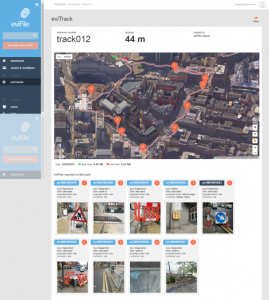
Complementing BIM, mobile geospatial services such as IDS’s eviFile will help infrastructure providers securely track their assets and associated processes. Over the past 2-3 years, I have had a number of conversations with Ed Williams, now client services director at the Leeds, UK-based IDS Group. When we first met, Ed was working on the concept …
Continue reading
Permanent link to this article: http://extranetevolution.com/2017/05/evifile-geo-located-progress-assurance/
Seattle, US-based startup Unearth has launched a cloud-based construction collaboration application that merges aerial and ground-level data, potentially capitalising on the growing use of site surveys via UAVs or drones. Its proposition is summed up as: “Unearth provides interactive aerial maps of your projects, secure storage for your build history, and simple collaboration for your entire …
Continue reading
Permanent link to this article: http://extranetevolution.com/2017/05/unearth-merges-aerial-and-ground-data/
Infrakit is particularly aimed at digital collaboration on infrastructure projects, with strong BIM and geospatial integrations. Keeping an eye and ear open for new SaaS construction software startups, I was pleased to hear from Helsinki, Finland-based startup Infrakit, particularly as it has strong relevance to the civil engineering sector, and also because of its focus on …
Continue reading
Permanent link to this article: http://extranetevolution.com/2016/04/infrakit-where-bim-meets-geospatial/